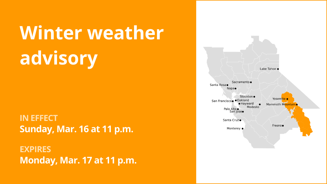
Yosemite is included in a winter weather advisory issued by the National Weather Service on Saturday at 10:08 a.m. The advisory is valid from Sunday 11 p.m. until Monday, Mar. 17 at 11 p.m.
The NWS Hanford CA said, “Snow expected at elevations mainly above 6,000 feet Sunday night lowering to around 5,000 feet by Monday afternoon. Total snow accumulations of 8 to 12 inches with locally heavier amounts possible. Winds gusting as high as 55 mph.”
“Travel could be very difficult to impossible. The hazardous conditions could impact the Monday morning and evening commutes. Strong winds could cause tree damage,” according to the NWS. “Slow down and use caution while traveling. The latest road conditions for the state you are calling from can be obtained by calling 5 1 1.”
The full list of affected locations includes:
Yosemite
Upper San Joaquin River
Kaiser to Rodgers Ridge
Kings Canyon NP
Grant Grove area
Sequoia NP
Winter driving essentials: Recommendations from the NWS for safe journeys
Winter weather can make driving treacherous, leading to over 6,000 weather-related vehicle fatalities and over 480,000 injuries each year. When traveling during snow or freezing rain, prioritize safety by slowing down. In near-freezing temperatures, it’s safest to assume that icy conditions exist on roadways and adjust your driving accordingly. Be cautious of ice accumulating on power lines or tree branches, which can lead to snapping and falling hazards. If possible, avoid driving in such conditions. If you must venture out, opt for routes with fewer trees and power lines. Never touch a downed power line, and immediately dial 911 if you come across one. Here are additional winter driving tips from the NWS:
Share your travel plans:
When venturing out of town in hazardous winter weather, be sure to inform family or friends of your destination, your intended route, and your estimated arrival time.
Prepare your vehicle:
Ensure your gas tank is full and equip your vehicle with essential winter supplies, including a windshield scraper, jumper cables, a small shovel, flashlight, cell phone, blanket, extra warm clothing, drinking water, and high-calorie non-perishable food.
Stay calm when stranded:
If you become stranded, stay composed. Notify someone about your situation and location. Avoid attempting to walk to safety. Attach a cloth to your car’s antenna or mirror to signal that you require assistance. Make your vehicle more visible by using the dome light and flashers.
Be mindful of snow plows:
Keep an eye out for snow plows and allow them ample room to pass. Only overtake a plow when you have a clear view of the road ahead.
Check road conditions:
Before embarking on your journey, verify the current road conditions to make informed travel decisions.
These winter driving tips from the NWS are your key to a safer journey on snow-covered roads. By following these guidelines, you can significantly reduce the risk of accidents and ensure your well-being during challenging winter weather.