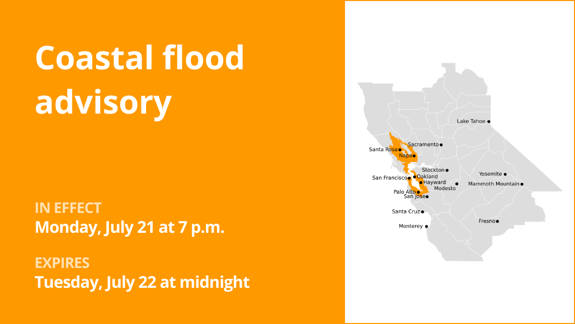
North Bay Interior Valleys and San Francisco Bay Shoreline as well as San Francisco County are the focus of an updated coastal flood advisory released at 9:04 p.m. on Monday by the National Weather Service. The advisory is in effect until Tuesday July 22, at midnight.
“Minor coastal flooding expected,” according to the NWS San Francisco CA. “Up to one foot inundation above ground level is possible in low-lying areas near shorelines and tidal waterways. At the San Francisco tidal gauge high tide is expected to be 1.04 feet above normal (6.88 ft MLLW) at 9:02 p.m. Monday. High tide timing varies up to 2 hours earlier or later along the coast and throughout the Bay.”
“Flooding of lots, parks, and roads with only isolated road closures expected,” the NWS said. “If travel is required, allow extra time as some roads may be closed. Do not drive around barricades or through water of unknown depth. Take the necessary actions to protect flood-prone property.”
How to use a sandbag and where to get sandbags in your area:
Follow these instructions on how to use sandbags and other flood preparation tips to protect your home, and click on the links below to get sandbags in your county:
Where to get sandbags in San Mateo County
Where to get sandbags in Alameda County
Where to get sandbags in Santa Clara County
Breaking down weather alerts: advisories, watches, and warnings
Flash flood warning: Take action!
A flash flood warning is issued when a flash flood is imminent or occurring. If you are in a flood-prone area, move immediately to high ground. A flash flood is a sudden violent flood that can take from minutes to hours to develop. It is even possible to experience a flash flood in areas not immediately receiving rain.
Flood warning: Take action!
A flood warning is declared when flooding is on the verge of happening or is already underway.
Flood advisory: Be aware:
A flood advisory is released when flooding is not expected to reach a severity level necessitating a warning. Nonetheless, it can still cause considerable inconvenience and, without exercising caution, potentially lead to situations that threaten life and/or property.
Flood watch: Be prepared:
A flood watch is issued when conditions are favorable for flooding. It does not mean flooding will occur, but it is possible.
When floods strike: Guidelines from the NWS for your protection
Floods can pose a significant threat, especially if you live in a flood-prone area or find yourself camping in a low-lying region. To ensure your safety, the NWS offers essential flood safety guidelines:
Move to higher ground:
If you reside in a flood-prone region or are camping in low-lying terrain, the first step to safety is relocating to higher ground.
Follow evacuation orders:
If local authorities issue an evacuation order, heed it promptly. Prior to leaving, secure your home by locking it.
Disconnect utilities and appliances:
If time permits, disconnect your utilities and appliances. This precaution minimizes electrical hazards during flooding.
Avoid basements and submerged areas:
Avoid basements or rooms submerged in water with electrical outlets or cords. Preventing electrical accidents is crucial.
Swift evacuation for your safety:
If you notice sparks or hear buzzing, crackling, snapping, or popping sounds, evacuate without delay. Do not enter water that may carry an electrical charge.
Stay away from floodwaters:
Never attempt to walk through floodwaters, even if they appear shallow. Just 6 inches of fast-moving water can forcefully sweep you off your feet.
Seek high ground if trapped:
Should you become trapped by moving water, reach the highest point possible and dial 911 to contact emergency services.
During heavy rainfall, the risk of flooding is heightened, especially in low-lying and flood-prone regions. Always remember never to drive through water on the road, no matter how shallow it appears. According to the NWS, as little as 12 inches of rapidly flowing water can carry away most vehicles. Stay safe by being prepared and informed.