Home

About Us

Advertisement

Contact Us

  • Facebook
  • X
  • Instagram
  • Pinterest
  • WhatsApp
  • RSS Feed
  • TikTok

Interesting For You 24

Your Trusted Voice Across the World.

    • Contacts
    • Privacy Policy
Search

Butler Fire map: Forecast of dry lightning prompts warnings of more evacuations

July 23, 2025
Butler Fire map: Forecast of dry lightning prompts warnings of more evacuations

Residents in the area of Siskiyou County’s Butler Fire were told to prepare to evacuate because of an ominous weather forecast.

Related Articles


Map: Butler Fire grows by 40% over weekend, more evacuations in Siskiyou County


5 dead in collision that sparks California brush fire


Southern California wildfire victims building ADUs as first step in home rebuilding process


Map: Butler Fire crosses Salmon River, more evacuations ordered


Map: Dale Fire evacuation zone

“Exceedingly dangerous conditions could result in multidirectional fire spread and spotting up to a mile,” said a warning late Tuesday from the county sheriff, adding: “If you are in an evacuation warning zone, gather your loved ones, pets, supplies and be fully ready to evacuate.”

The Klamath Mountains are under a fire weather watch from 9 a.m. to 11 p.m. Thursday, with dry thunderstorms and downforce winds expected, the National Weather Service said.

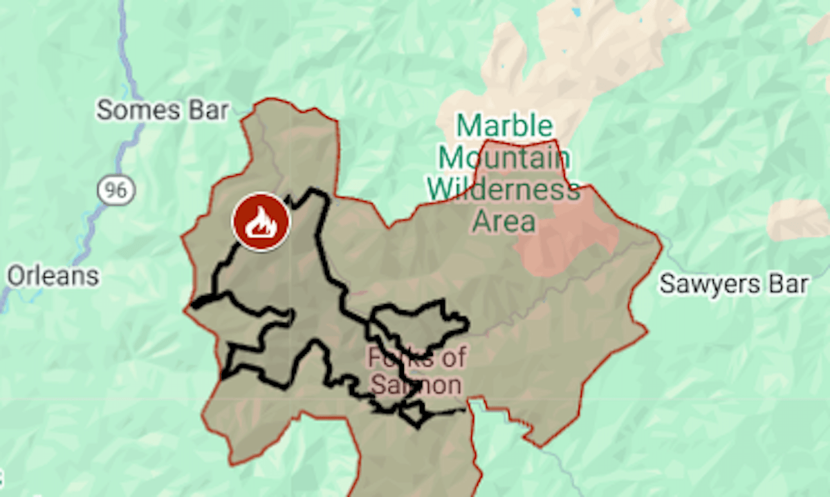
The wildfire, sparked by lightning on July 3, was mapped at 18,474 acres (29 square miles) with 9% containment, the National Forest Service’s fire managers said on Wednesday, July 23.

Most of the growth this week has been to the south, and one evacuation zone at the fire’s north edge was downgraded to a warning on Wednesday.

The map above shows the evacuation area in red and the approximate fire perimeter as a black line. For updates and details of the evacuation, including warning areas, see the Genasys Protect map or the Siskiyou County emergency website.

Butler is California’s fourth-biggest wildfire of the year, after Madre (San Luis Obispo County, 80,799 acres), Palisades (Los Angeles County, 23,448) and Green (Shasta County, 19,022). Green was 60% contained as of Wednesday, and its evacuation order, in effect since July 11, was downgraded to a warning.

Featured Articles

  • Santa Clara County real estate: House on Quail Cliff Way sells for $2,925,000

    Santa Clara County real estate: House on Quail Cliff Way sells for $2,925,000

    July 24, 2025
  • French president sues right-wing podcaster over false claims

    French president sues right-wing podcaster over false claims

    July 24, 2025
  • Appeals court finds Trump’s effort to end birthright citizenship unconstitutional, upholds block

    Appeals court finds Trump’s effort to end birthright citizenship unconstitutional, upholds block

    July 24, 2025
  • Five-bedroom home sells for $2.5 million in San Ramon

    Five-bedroom home sells for $2.5 million in San Ramon

    July 23, 2025
  • Santana Row stabbing: Judge finds two teens responsible for beating 15-year-old

    Santana Row stabbing: Judge finds two teens responsible for beating 15-year-old

    July 23, 2025

Search

Latest Articles

  • Santa Clara County real estate: House on Quail Cliff Way sells for $2,925,000

    Santa Clara County real estate: House on Quail Cliff Way sells for $2,925,000

    July 24, 2025
  • French president sues right-wing podcaster over false claims

    French president sues right-wing podcaster over false claims

    July 24, 2025
  • Appeals court finds Trump’s effort to end birthright citizenship unconstitutional, upholds block

    Appeals court finds Trump’s effort to end birthright citizenship unconstitutional, upholds block

    July 24, 2025

181 Peachtree St NE, Atlanta, GA 30303 | +14046590400 | [email protected]

Scroll to Top