During the Bay Area’s glorious summers, residents and visitors alike love to get out in nature, sometimes on leisurely local strolls, or with a little preparation, serious hikes where various terrains and micro-climates are on offer. Here are some favorite hikes to enjoy that variety and avoid the more scorching inland temperatures.
Related Articles
Largest campground at Yosemite National Park to reopen after $26 million renovation
2 Bay Area cities among America’s best for sober traveling
Summer Road Trip Playlist: 15 great Bay Area songs to fuel your travels
Road Trip: Spend a day on the Bay, al fresco-style
California is natural habitat for mountain lions. Here’s what you can do if you encounter one
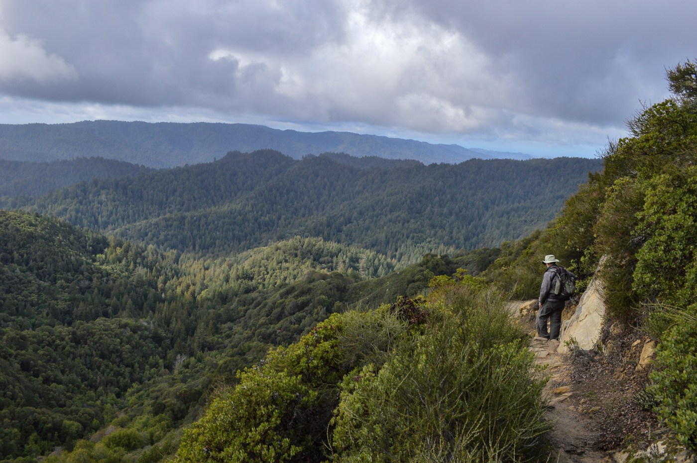
Coast Trail from Bolinas into Point Reyes National Seashore
If the Bay Area falls under another weeks-long “heat dome” like last summer, your best chance for relief is to head to the ocean. The some 200 miles of coastline from Santa Cruz to Sea Ranch offer countless opportunities to catch cool Pacific breezes while hiking along towering cliffs or down to hidden beaches.
This approximately 6-mile, out-and-back hike into Point Reyes National Seashore provides cliffs, breezes and a potential beach opportunity, plus also something unique to the Bay Area: The chance to visit a picturesque, naturally occurring lake – not a human-made reservoir – in the middle of a lush forest. This body of water, Bass Lake, also is a not-so-secret swimming spot.
The shore of Bass Lake, a popular though unofficial swimming spot in Point Reyes National Seashore, which can be reached via the Coast Trail. (Martha Ross/Bay Area News Group)
The hike starts at the Palomarin Trailhead, approximately 5 miles northwest of Bolinas. The trail initially passes through a grove of eucalyptus with extravagantly intertwined trunks before coming out into the open along the top of a bluff, high above the churning Pacific. On days when inland temperatures exceed 100 degrees, nature provides its own air-conditioning in the form of wisps of fog blowing up from the ocean.
The hike dips down into a valley before crossing a bridge and switchbacking up the other side and over a pass that brings you into a forest that is part of the Phillip Burton Wilderness. You’ll pass several small ponds before reaching Bass Lake. An unmaintained spur trail winds along the northwest side of the lake, a nice spot for a picnic near the water. Park staff, however, warn that access to the lake is limited, as its shores are largely surrounded by thick tangles of vegetation, including poison oak. There are no lifeguards, so “swim at your own risk,” rangers say.
Hikers can continue along the Coast Trail to other popular destinations. For an ambitious 13-mile roundtrip, you’ll pass by Pelican Lake, another naturally occurring body of water, before reaching dramatic Alamere Falls. Here, water cascades over a 40-foot cliff onto a small beach below, but rangers warn that the beach is only accessible at low tide.
Details: For day visitors, the park is open 6 a.m. to midnight, year-round, and there is no fee. The Palomarin Trailhead is at the northwestern end of Mesa Road; the last 1.2 miles of Mesa Road is unpaved and severely potholed. There are portable toilets at the trailhead but no water, so be sure to bring your own. https://www.nps.gov/
And afterward … Head south on Highway 1 to Stinson Beach and the Parkside Cafe, whose beachside snack bar has been serving hamburgers, hot dogs, shakes and its famous half ‘n half soft ice cream cones since 1949. There’s also a sit-down restaurant, serving breakfast, lunch, dinner and cocktails, with an emphasis on seafood dishes. www.parksidecafe.com
Chill in the redwoods of Oakland and the Santa Cruz mountains
Thanks to conservationists, the Bay Area is home to more than 40 parks where you can immerse yourself in forests of coast redwoods, those giants that grow taller than skyscrapers, nurture entire ecosystems and live for centuries. These forests also offer acres of shade and gentle, cool breezes on hot summer days.
Visitors enjoy the weather and sightseeing as the hike along Stream Trail at the Redwood Regional Park in Oakland, Calif., on Friday, April 21, 2023. (Ray Chavez/Bay Area News Group)
Some of these parks are wonderfully close to civilization. In the hills between Oakland and the East Bay suburbs, Dr. Aurelia Reinhardt Redwood Regional Park is a lush, 1,833-acre strip of forest made up of second- and third-generation clones of ancient trees that were lost to clear-cutting in the 1800s to support the booming Bay Area’s need for timber. Still, this forest is magnificent, accented by ferns, grasses and flowering plants that come in infinite shades of green.
A popular route is the French Trail Loop. It starts at the Canyon Meadow Staging Area and can go on for 4 to 6 miles, depending on which connector paths you choose. Any version, though, begins with a pleasant, mostly level stroll along the Stream Trail, which follows the course of Redwood Creek.
For a redwood park that is much more remote, try Portola Redwoods State Park, nestled deep in the Santa Cruz Mountains. Two narrow winding roads from Skyline Boulevard take you down into a forest, where you may find near-total silence as you follow meandering creeks and pass through some of the Bay Area’s oldest redwood trees
LA HONDA, CALIFORNIA – OCTOBER 20: People hike along the Old Tree Trail at Portola Redwoods State Park in La Honda, Calif., on Tuesday, Oct. 20, 2020. (Nhat V. Meyer/Bay Area News Group)
An easy 1.2-mile roundtrip hike leads to Old Tree, which is more than 300 feet tall and estimated to be more than 1,200 years old. This hike spotlights trees with charred trunks that survived forest fires centuries ago — and which continue to thrive. For the much more ambitious, there’s a nearly 12-mile trek into Peters Creek Grove, nestled deep within the park and consisting of mammoth, old-growth redwoods.
Details: Reinhardt Redwood Regional Park, at 7867 Redwood Road, Oakland, is open to day visitors from 8 a.m. to 8 p.m. through the end of September, with a $5 vehicle day-use fee. www.ebparks.org/. Portola Redwoods State Park, off Alpine Road and at the end of Portola State Park Road, is open to day visitors from 6 a.m. to sunset with a $10 vehicle day-use fee.
And afterward: From Reinhardt Redwood Regional Park, head to the Fourth Bore Tap Room in Orinda’s Theatre Square for craft beer and hearty pub fare, including Angus steak skewers, pulled pork nachos and pizzas, and live music on weekends. https://thefourthbore.com. For Portola Redwoods State Park, you’ll need to travel back into civilization for a meal. The closest option is Alice’s Restaurant, a favorite destination for hikers, bikers, artists and entrepreneurs. It serves gourmet burgers, scrambles, housemade pies and local wines and beer. Open daily at 17288 Skyline Blvd. in Woodside; www.alicesrestaurant.com.
Saratoga and Ridge trails to and from Goat Rock
For nearly a century, massive sandstone outcroppings and rock walls have offered tantalizing destinations for serious climbers at this 5,200-acre state park in the Santa Cruz Mountains. Don’t worry: You don’t have to be one of those die-hards to enjoy these attractions, though a 3-mile loop to the top of dramatic 2,920-foot Goat Rock still requires scrambling over big rocks.
Of course, the views from Goat Rock are worth the effort. On a clear day, you can see the mountains that are the home to Big Basin, Butano and other state and county parks, along with the San Lorenzo River Valley to Monterey Bay and the blue Pacific Ocean beyond. The hike to Goat Rock, along the Saratoga Gap Trail, will also take you past another popular park attraction: Castle Rock Falls.
Castle Rock State Park (Courtesy of California State Parks, 2025)
The trail descends a little over half a mile through a forest of oaks and mixed evergreens to Kings Creek, a tributary of the San Lorenzo River. After crossing the creek at a footbridge, continue left along the trail, which takes you to a viewing platform for the falls. When Kings Creek is still flowing, its drops some 75 feet into a canyon below. From this platform, you might also catch climbers attempting to ascend the sheer rock face.
Continuing along the trail, the tree canopy gives way to open scrubby chaparral, low manzanitas, breezes off the ocean and a view of the final destination: Goat Rock. No, this outcropping doesn’t look like a goat, but it’s still pretty distinctive: some 100 feet tall from its base and pocked with deep cavities. The trail here becomes more challenging, running up and over sandstone boulders that protrude out of the side of the mountain and require balance, thigh power and resistance to acrophobia. At about 1.4 miles, you can take the Interconnector Trail up to the Ridge Trail, which winds through black oaks to the top of Goat Rock, with its panorama of mountains, sky and ocean.
Details: The park’s main entrance, at 15451 Skyline Blvd., is open 6 a.m. to sunset, with a large parking lot and a $10 vehicle day-use fee. Here, there are restrooms, a native plant garden and a .08-mile path from the parking lot that leads to an ADA-compliant picnic table with woodland views.
And afterward… Drive down the mountain from Skyline Boulevard and stop in picturesque Saratoga and Sue’s Gallery Cafe, which serves vanilla lattes, Aztec mochas and a variety of teas and artfully created toasts and flatbreads, topped with avocado, Mascarpone Cheese or ham and pesto. https://suesgallerycafe.com
Elderberry Trail to Rocky Ridge, Las Trampas Wilderness Regional Preserve, San Ramon
On a sun-scorched day in the middle of summer, you’d frankly want to avoid many hikes in the East Bay hills – unless you started in the cool early morning or you’re one of those Death Valley marathoners.
Rocky Ridge in Las Tampas Regional Wilderness Preserve, looking south toward San Ramon, Dublin and the Livermore Valley. (Courtesy of East Bay Regional Park District)
But on a mild day, the Elderberry Trail hike to the top of Rocky Ridge in Las Trampas Wilderness Regional Preserve offers a pleasantly strenuous climb through cool, shady groves of oaks and buckeyes and the promise of stunning views at the top. Once you’ve ascended to long, open Rocky Ridge, you can gaze upon the surrounding wildlands and beyond –the Santa Cruz Mountains, San Francisco Bay and the city skyline in the west; Mount Diablo to the east; and Livermore Valley and the craggy peaks of Sunol Regional Wilderness to the south. Whether the ridge is enshrouded by summer fog or bathed in sun, you’re likely to encounter brisk winds blowing in from the bay and Golden Gate.
The Elderberry Trail can be the first leg of a popular loop that is roughly 5 miles long. From the staging area at the end of Bollinger Canyon Road, this wide dirt tract ambles south for about a half mile along Bollinger Canyon creek, next to a pasture populated by grazing cattle. It veers right for a short, intense climb before it follows a somewhat more steady wind up to the ridge.
You have the option to follow the Rocky Ridge Trail for another mile and a half and enjoy more of those commanding views before it loops back down onto another fire road. But from the top of the ridge, you can also take a side trip. The most popular is a strenuous hike down about 700 feet into a box canyon, via the Devil’s Hole or Sycamore trails, and then back up. This trail will take you past rock formations, including “a wind cave,” which are remnants of prehistoric sea life. While spring is the best time to see an array of wildflowers in Las Trampas, hikers have reported seeing poppies and lupins in the early fall.
Details: Through Sept. 3, the park is open from 8 a.m. to 8 p.m. and then open to 7 p.m. through Nov. 1. The staging area and parking at the end of Bollinger Canyon has restrooms, picnic tables and water fountains. There is no charge for parking. Cell service is spotty here, so download any maps or pick up a free paper map before hitting the trail, www.ebparks.org
And afterward… Enjoy a sweet treat at Salt & Straw, the artisanal ice cream shop in San Ramon’s City Center that is known for adventurous flavors like chocolate chili crisp, pear and blue cheese and, our favorite, lavender honey. https://saltandstraw.com/