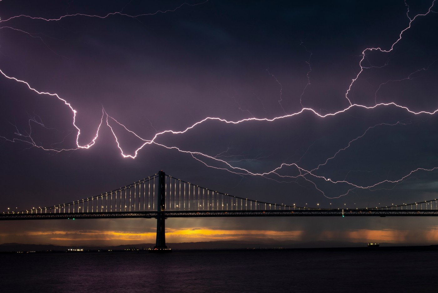
An overnight light show early Tuesday brought drama to the unofficial end of summer, opening the post-Labor Day workweek with thousands of lightning strikes that filled the sky from from the Bay Area to the Central Valley.
The lightning came from increasingly unstable air and sparked a “number of fires,” the National Weather Service said. According to Cal Fire, none of those had grown into a major wildfire by 8 a.m. Tuesday.
Related Articles
Pickett Fire: Napa wildfire not expected to spread further as crews boost containment to 29%
Garnet Fire: Firefighters try to corral forest blaze as lightning strikes bring risk of new ignitions
Pickett Fire: Fire crews increase containment to 17%
During heat wave, a list of some Bay Area cooling centers
Heat wave worthy of summer settles into Bay Area
“Generally speaking, it’s tapering off,” NWS meteorologist Roger Gass said of the lightning early Tuesday. “But we can’t rule out some isolated thunderstorms later Tuesday around the East Bay.”
By 5:30 a.m. Tuesday, the weather service had recorded about 4,800 lightning strikes from Sacramento to San Luis Obispo, including 1,300 that touched the ground.
The weather service said an unknown amount of fires started overnight in southeast Monterey County and in southwestern Fresno County early Tuesday. It was not known immediately how big any of those fires were, but Cal Fire had not reported any new ones on its list of California’s major blazes.
Of concern is the Garnet Fire in Fresno County, which according to Cal Fire started Aug. 24 and has burned 26,982 acres. That blaze was 12% contained, and forecasters are concerned that lightning strikes Tuesday could create more fires within the larger fire’s boundaries.
The lightning came with low rumblings of thunder and in some areas light bits of rain that were too small to measure, Gass said. It developed quickly as monsoonal moisture from the southern part of the Pacific Ocean and the southwestern desert shifted course and moved north, he said.
“There already was a trough of low pressure in the upper part of the atmosphere,” Gass said. “Then you had the monsoonal moisture that worked its way into our area.”
Those two elements created an imbalance of high and low pressure that coated the Central Valley and Monterey County and extended to areas near Concord and San Jose, Gass said. That imbalance led to instability that brings with it thunder and lightning.
The electric show is expected to be finished by the time Tuesday turns into Wednesday, though Gass said the timeline for how long the weather pattern sticks around is unclear.
“As the trough moves inland, it’ll shift the high pressure to the east,” Gass said. “Then, we’ll see a cooling trend the rest of the week.”
The high temperatures might reach 90 in the hottest spots Tuesday, with the humidity running close to 40%, according to the weather service. By the end of the work week, temperatures likely won’t get much past 80 degrees in the hottest spots, though the humidity is expected to climb above 50%.
Temperatures Monday reached 100 degrees in some East Bay spots and 90 degrees in San Jose, capping a weekend that proved hotter than forecasters originally anticipated. That heat came with more than a hint of humidity Monday because of the monsoonal air.