Fires sparked by Labor Day lightning storms brought a jolt of activity to California’s fire season, which has been comparatively mild over the summer.
Related Articles
Quick-moving wildfire scorches historic California gold mining town, burning multiple homes
Map: 8 fires in TCU Lightning Complex and Gold Country evacuations
PG&E monthly bills fall as some wildfire and emergency costs recede
As summer fades, Bay Area gets a lightning show
Map: Garnet Fire evacuation zone still expanding after a week
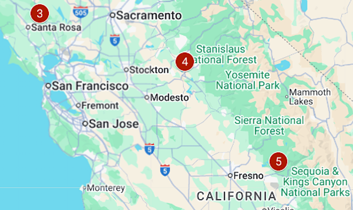
The map above shows where some notable fires are burning in the first week of September.
1 & 2 / Dillon and Blue. Dillon is in its second week, having started during an earlier round of lightning strikes, on Aug. 25. It has burned more than 8,000 acres; evacuation orders remain in place for residents along the Klamath River in the Cottage Grove area [see map: perimeter and evacuations]. Blue was started by lightning a day later and about 25 miles to the northeast, and is at 1,600 acres.
3 / Pickett. The biggest Bay Area fire of the season is 91% contained, and the last evacuation orders and warnings were lifted on Tuesday, Sept. 2. Pickett started on Aug. 21 on the edge of Calistoga and has burned 6,819 acres. Its cause is under investigation, said the California Department of Forestry and Fire Protection.
4/ TCU September Lightning Complex. The complex comprises eight fires that were started by lightning on the night of Labor Day and into the following morning. The largest, called 6-5, has burned almost 6,500 acres near Don Pedro Reservoir. Evacuations have been ordered for that fire and 2-7, burning along Highway 4 near Murphys [see map: perimeters and evacuations].
5/ Garnet. The third-biggest California fire of the year was started by lightning on Aug. 24 and has burned almost 30,000 acres. It is 12% contained. Evacuation orders cover almost 370 square miles of the Sierra National Forest in Fresno County [see map: perimeter and evacuations].
6/ Salt 14-2. It started in the early hours of Tuesday, Sept. 2, and in barely 24 hours burned 5,000 acres. The evacuation order issued late Tuesday covers a sparsely inhabited area south of Coalinga.