For generations, fire lookout towers stood as landmarks across the American West.
Binoculars in hand, dedicated fire spotters scanned the landscape for smoke and radioed firefighters before flames grew out of control. But now, as California enters what is historically the most dangerous part of fire season — the end of summer before the first major rains — lone human sentries have largely given way to a new type of fire lookout on mountain tops: high-tech cameras.
What began as a small research project at UC San Diego 25 years ago has grown into a powerful network of 1,211 cameras constructed on peaks and hilltops across the state with millions of dollars in state funding and oversight from Cal Fire.
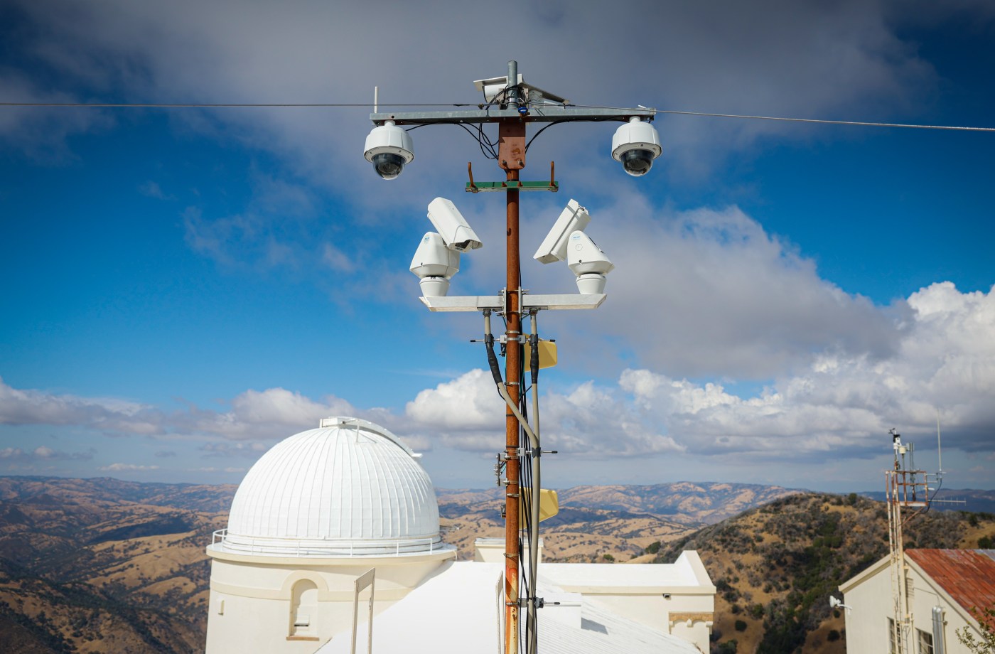
Built on towers, observatories and buildings, the cameras are part of a system called ALERTCalifornia. They turn 360 degrees every 2 minutes, taking 12 photos with each pass, 24 hours a day. Upgraded with artificial intelligence software two years ago, they can pan, tilt, zoom, detect smoke and alert fire dispatchers automatically — sometimes before humans call 911.
Each can see 60 miles away on a clear day, and with near-infrared technology, gaze out 120 miles on a clear night.
“Lookouts get up in the morning and work until dusk. But this is 24-7,” said Brian York, deputy chief for fire intelligence at Cal Fire.
“We measure success in all the times that we respond and put out the fires that you never hear about,” he said. “Especially in rural areas at night when most people are sleeping.”
Since 2019, the number of cameras has more than doubled.
The AI lookouts are now on top of many of California’s most prominent peaks, including Mount Hamilton, Mount Diablo and Mount Tamalpais in the Bay Area, Martis Peak at Lake Tahoe, Mammoth Mountain in the Sierra, and the slopes of Mount Shasta.
Related Articles
These are the wildfire-related bills the California Legislature OK’d this year
San Jose: Cluster of fires near Communications Hill being investigated as arson
Threat of Bay Area dry lightning lessens as hot spell begins to fade
California’s FAIR Plan would face more scrutiny under bill heading to Newsom’s desk
California Legislature passes a swath of last-minute energy bills
The cameras have been used to monitor atmospheric river storms, the recovery of California condors, even a tsunami warning along California’s coast in July after an 8.8 magnitude earthquake off Russia. They can be found on Southern California peaks like Mount Wilson near Los Angeles, Cowles Mountain in San Diego, and even on Catalina Island, along with the top of the Dream Inn in Santa Cruz and the roof of the Oakland Coliseum.
Anyone can view the camera feeds live at alertcalifornia.org.
“They are here to help during emergencies,” said Caitlin Scully, UC San Diego spokeswoman. “But they are used all the time by so many different groups. Because they are available for free, people use them to watch big storms, or even check the conditions up in the Sierra when they want to go for a hike.”
The network is based at UC San Diego’s Jacobs School of Engineering, the Qualcomm Institute and the Scripps Institution of Oceanography. It is run and maintained by UC San Diego, with Cal Fire, large utilities like PG&E, Southern California Edison, San Diego Gas & Electric and other partners contributing locations and camera equipment.
From 2019 to 2024, Cal Fire contributed at least $24 million to expanding the system.
New fire departments and other agencies sign up to be partners, and their officials are given access to pan and zoom in the cameras. Last month, East Bay Regional Park District, which has 126,809 acres of parkland across 73 parks in Alameda and Contra Costa counties, signed on.
The network isn’t without its shortcomings.
To address privacy concerns, UC San Diego blurs homes, parking lots and other nearby features that could track people in real time.
The AI system, developed by a DigitalPath, a Chico company, also can’t always tell smoke from dust storms, clouds or other false positives. Its software had to be taught not to report steam from the Geysers geothermal fields in Sonoma County. And in big urban fires, like in Los Angeles in January, residents with cell phones report fires almost as soon as they begin.
“The biggest advantage with them is that we can monitor fires now as they are ongoing,” said Craig Clements, director of the Fire Weather Lab at San Jose State University. “There are limitations with detection. The cameras can see smoke and sometimes hot spots. They can’t see through mountains. And if a fire starts at the bottom of a canyon, you aren’t going to see it. AI and smoke detection are still in their infancy.”
Remote video cameras operated by the ALERTCalifornia network display live landscapes across California as CalFire communications operator Javier Garcia monitors from the CalFire Dispatch Center in Morgan Hill, Calif., on Thursday, Sept. 11, 2025. The ALERTCalifornia network is a system with over 1,200 remote cameras placed on mountains and hills throughout California, which scan their surroundings for smoke and automatically notify fire dispatchers. (Ray Chavez/Bay Area News Group)
Clements said the technology also may be overtaken in the years ahead by high-tech satellites.
But for now, he said, it is very useful for fire commanders, meteorologists and researchers to learn about fire behavior in real time as huge fires are exploding across the landscape.
“I look at it all the time,” Clements said. “You can’t get flame heights, spread rates and things like that. But I look at the plume structure, how thick the smoke plume is — things you can’t see on satellite. That shows you the state of the fire, and gives you a sense of the fire’s intensity.”
The cameras don’t dispatch fire engines, helicopters or airplanes on their own.
They send a message to dispatch centers across the state, which is then verified by humans.
Last year, there were 7,553 wildfires in Cal Fire’s jurisdiction. Of those, 1,668 were picked up by the cameras, said Cal Fire’s York. And 38%, or 636, were detected by the cameras before any person called 911 to report them.
In one such case on July 6, an AI camera posted an alert at 2:33 am of a fire near Auburn, in the foothills east of Sacramento. Nobody had called 911. Cal Fire’s Grass Valley Emergency Command Center verified it and sent engines. Fire crews found a fire and put it out before it spread beyond a 30 x 30 foot area.
“It was a perfect example of a fire that doesn’t gain attention because it was detected early and extinguished while still small,” York said.
Fire lookout towers with human fire spotters are going the way of the phone booth and fax machine. Where there were once more than 600 in the 1940s, 50s and 60s, today there are only 217 left in California, according to Forest Fire Lookout Association. Only about 50 of the sites are regularly staffed now, mostly with volunteers.
Cell phones, automated cameras, more airplane flights and more people living in rural areas have reduced their effectiveness.
Jamey Erikson, superintendent at Lick Observatory atop Mount Hamilton in the hills east of San Jose, said old paper directions are still posted in offices there telling people how to report the coordinates of fires. But the three ALERTCalifornia cameras at the observatory have made that largely obsolete, he said.
“I use the cameras religiously to look for smoke, to check the weather,” he said. “They are essential.”

