Home

About Us

Advertisement

Contact Us

  • Facebook
  • X
  • Instagram
  • Pinterest
  • WhatsApp
  • RSS Feed
  • TikTok

Interesting For You 24

Your Trusted Voice Across the World.

    • Contacts
    • Privacy Policy
Search

Map: Gifford Fire evacuation zone expanded amid ominous forecast

August 6, 2025
Map: Gifford Fire evacuation zone expanded amid ominous forecast

With fire crews bracing for hotter, dryer weather, the evacuation zone was expanded for California’s biggest fire of the season.

Related Articles


New studies tie unrecognized deaths and health problems to California and Hawaii wildfires


Los Gatos resident takes extra steps to protect hillside home from wildfires


Gifford Fire: Massive blaze in central California threatens more than 800 structures and leaves 3 injured


Map: Gifford Fire grows 10,000 acres overnight to become California’s biggest wildfire of 2025


Car fire on I-580 sparks vegetation fire

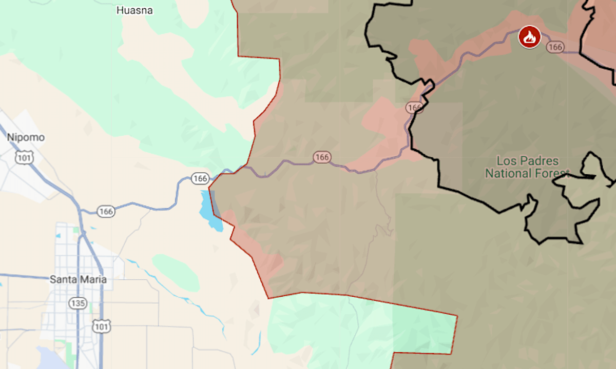
Wednesday’s new orders were for an area near the north edge of the Gifford Fire, burning since last week in San Luis Obispo and Santa Barbara counties. The expansion brought the zone to 660 square miles.

Fire managers for the U.S. Forest Service had not revised the previous day’s estimate of the fire’s size — 83,932 acres, or 131 square miles, with 9% containment.

On Tuesday morning, Gifford became the state’s biggest fire of 2025, surpassing Madre, which last month burned 80,779 acres just to the east, in the Carrizo Plain area.

The map above shows Gifford’s evacuation area in red and the approximate fire perimeter as a black line. Shown as a gray tone is the Madre Fire perimeter.

The Gifford Fire started on Friday, Aug. 1, along Highway 166 east of Santa Maria. The cause is under investigation. About 2,300 firefighters have been contending with rugged terrain in the sparsely inhabited area.

Wednesday’s report from the Forest Service team said a warming and drying trend is expected to continue until the weekend. “Thursday could see temperatures into triple digits, increasing fire behavior,” it said.

For updates and details of the evacuation, including warning areas, see the Genasys Protect map for Santa Barbara County or the San Luis Obispo County emergency site.

Featured Articles

  • Dodgers rally to beat Blue Jays in Game 7, become first repeat champ in 25 years

    Dodgers rally to beat Blue Jays in Game 7, become first repeat champ in 25 years

    November 2, 2025
  • Warriors instant analysis: Golden State squanders fourth quarter lead against injury-riddled Pacers

    Warriors instant analysis: Golden State squanders fourth quarter lead against injury-riddled Pacers

    November 2, 2025
  • High school football in pictures: Highlights captured from Week 10, 2025

    High school football in pictures: Highlights captured from Week 10, 2025

    November 2, 2025
  • Cal misses its shot to beat No. 15 Virginia and become bowl eligible as Bears fall 31-21 at home

    Cal misses its shot to beat No. 15 Virginia and become bowl eligible as Bears fall 31-21 at home

    November 1, 2025
  • Livermore gun shop reloading security, merchandise after recent heist

    Livermore gun shop reloading security, merchandise after recent heist

    November 1, 2025

Search

Latest Articles

  • Dodgers rally to beat Blue Jays in Game 7, become first repeat champ in 25 years

    Dodgers rally to beat Blue Jays in Game 7, become first repeat champ in 25 years

    November 2, 2025
  • Warriors instant analysis: Golden State squanders fourth quarter lead against injury-riddled Pacers

    Warriors instant analysis: Golden State squanders fourth quarter lead against injury-riddled Pacers

    November 2, 2025
  • High school football in pictures: Highlights captured from Week 10, 2025

    High school football in pictures: Highlights captured from Week 10, 2025

    November 2, 2025

181 Peachtree St NE, Atlanta, GA 30303 | +14046590400 | [email protected]

Scroll to Top