The statewide Sierra Nevada snowpack, which provides nearly one-third of California’s water supply, began the year in good shape, at 108% of normal.
But as anyone who went skiing or did yardwork over the past month knows, January was very dry, which contributed to the Los Angeles wildfires, and growing nervousness among water managers across the state.
On Friday, the statewide Sierra snowpack had fallen to just 65% of its historical average for this time of year. The good news is that at won’t last long. Northern California began being pounded by a series of storms Friday that are expected to bring considerable amounts of snow and rain for at least a week — a key boost to improve the state’s water outlook.
“The year began fairly well, better than last year,” said Andrew Schwartz, lead scientist at the UC Berkeley Central Sierra Snow Laboratory, near Donner Summit. “We had a nice big atmospheric river in November and another in December that put us above average. Then the tap shut off.”
Until Friday morning, it hadn’t snowed at all at the lab since Jan. 4. That 27-day run is the fourth-longest dry spell during any winter since 1971, with only 2022, 1991 and 1971 having longer snow-free periods.
But now, two or three new storms heading in from the Pacific are forecast to dump up to 5 feet of new snow in the Lake Tahoe area by next Friday, Schwartz said.
“These storms should bring us up to normal again, if not above,” Schwartz said. “It was getting concerning. You definitely want the storm window to open, and that’s what’s happening now. It’s going to help us a lot.”
California has struggled with three severe droughts over the past generation: From 2007-2009, then 2012-2016, and most recently from 2020-2022.
The past two winters have seen above average rain and snow, however, leaving most of the state’s major reservoirs currently at or above historical averages.
On Friday, Shasta Lake, the state’s largest reservoir, near Redding, was 76% full, while the second-largest — Oroville, in Butte County — was 75% full, and San Luis Reservoir, east of Gilroy, was also 75% full. To the south, Diamond Valley, a major off-stream reservoir in Riverside County that is key to water supplies in Los Angeles and surrounding cities, was 97% full.
So far, this winter has been marked by a stunning difference in rain and snowfall between Northern California and Southern California. And that’s continuing with the new round of storms.
On Friday, the snowpack in the Northern Sierra was 93% of average, and in the Central Sierra it was 59%. But in the Southern Sierra, it was only 46%.
Rainfall totals this winter have been even more uneven. The farther north that communities are located, the more rain they have received. Since Oct. 1, Santa Rosa rainfall totals are 140% of average. San Francisco is at 83%. San Jose is at 55%. And Los Angeles is at 10%.
The last time the Bay Area received any significant rain was Jan. 3. It hasn’t had 1 inch or more in a single day in seven weeks — since Dec. 14.
That’s because of a ridge of high pressure that built up off the coast, blocking many storms. That ridge has now dissipated, ushering in wet weather. Rain will continue Saturday, Sunday and Monday, off and on, and is expected to peak Monday night into Tuesday, with dry conditions Wednesday and more on Thursday.
“This isn’t one big humongous storm,” said Jan Null, a meteorologist with Golden Gate Weather Services in Half Moon Bay. “It’s a series of modest-sized storms that are going to be spinning in.”
The storms could dump about 2 to 3 inches of rain over the next week to the Bay Area, forecasters say, which would be enough to bring averages in many cities back to near normal.
The National Weather Service issued a flood watch for most of the Bay Area and the Central Valley from noon Friday until 10 p.m. Saturday. Forecasters there said there is as chance in low-lying areas of some creek flooding, water on roadways and blocked rains. But widespread flooding is not expected, Null noted, because it hasn’t rained for a month and river levels are low.
The impact on the Sierra Nevada, California’s largest mountain range, is expected to be more significant. The National Weather Service has a winter storm warning in effect until 4 a.m. Sunday for the Yosemite National Park area, with up to 3 feet of snow expected by Sunday, and a winter storm watch for the Northern Sierra over the same time with up to 2 feet of snow expected.
“The storms will push this part of the state back to average or above average,” said Andy Reising, manager of the Snow Surveys and Water Supply Forecasting Unit at the state Department of Water Resources. “But they will not bless Southern California with much precipitation at all.”
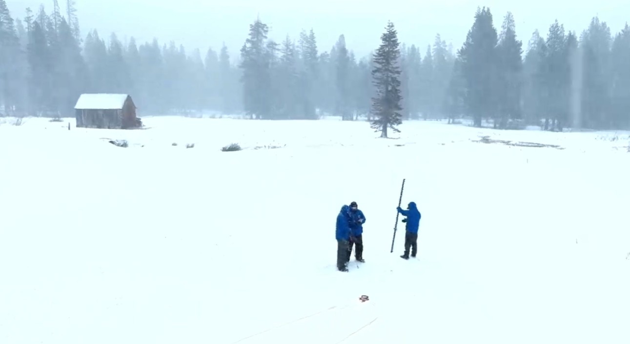
On Friday, officials from the department took their second monthly manual snow reading of the at Phillips Station, an area 90 miles east of Sacramento off U.S. Highway 50 in El Dorado County.
The department has 260 locations across the Sierra that it measures to forecast how much snow has fallen, how much water it holds, and how much runoff the state’s cities and farms can expect each spring and summer into rivers and reservoirs.
Snow fell steadily at Phillips Station as he spoke with journalists.
“We’ll definitely need more storms in the next few months,” he said, “to make up for the dry January.”